
Make a donation
Gear up for your next adventure:
As an Amazon Associate, this site earns from qualifying purchases at no extra cost to you.
Afonsim topographic map
Click on the map to display elevation.
Make a donation
Gear up for your next adventure:
As an Amazon Associate, this site earns from qualifying purchases at no extra cost to you.
About this map
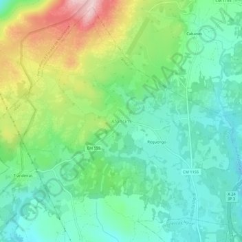
Name: Afonsim topographic map, elevation, terrain.
Location: Afonsim, Vila Pouca de Aguiar, Vila Real, 5450-001, Portugal (41.50636 -7.70138 41.54636 -7.66138)
Average elevation: 978 m
Minimum elevation: 892 m
Maximum elevation: 1,165 m
Make a donation
Gear up for your next adventure:
As an Amazon Associate, this site earns from qualifying purchases at no extra cost to you.
Other topographic maps
Click on a map to view its topography, its elevation and its terrain.
Make a donation
Gear up for your next adventure:
As an Amazon Associate, this site earns from qualifying purchases at no extra cost to you.
Barragem da Falperra
Portugal > Vila Real > Vila Pouca de Aguiar > Soutelo de Aguiar
Average elevation: 911 m
Make a donation
Gear up for your next adventure:
As an Amazon Associate, this site earns from qualifying purchases at no extra cost to you.
Albufeira da Barragem da Falperra (Lagoa do Alvão)
Portugal > Vila Real > Vila Pouca de Aguiar > Soutelo de Aguiar
Average elevation: 901 m