Geolocate

Osbaldwick topographic map

Click on the map to display elevation.

About this map

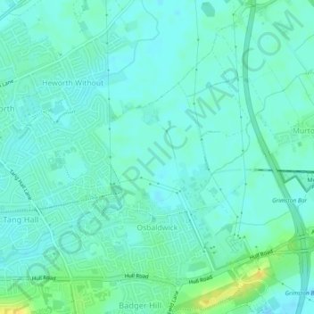
Name: Osbaldwick topographic map, elevation, terrain.

Location: Osbaldwick, York, England, United Kingdom (53.95377 -1.04702 53.97480 -1.01752)

Average elevation: 16 m

Minimum elevation: 10 m

Maximum elevation: 32 m

Gear up for your next adventure:

🥾Lightweight Hiking Shoes - Comfortable shoes for day hikes
🧥Waterproof Pants - Keep dry during rainy hiking conditions
🩹Moleskin Blister Pads - Direct protection for painful foot pressure points
🦶Anti-Blister Balm - Prevents friction and hotspots during long ascents
🥘Camping Cookware Set - Compact nesting pots and pans for trail cooking

As an Amazon Associate, this site earns from qualifying purchases at no extra cost to you.