
Make a donation
Gear up for your next adventure:
As an Amazon Associate, this site earns from qualifying purchases at no extra cost to you.
Lecco topographic map
Click on the map to display elevation.
Make a donation
Gear up for your next adventure:
As an Amazon Associate, this site earns from qualifying purchases at no extra cost to you.
Lecco
The territory has a very variable altitude distribution: it ranges from 198 metres (650 ft) above sea level in the lake area to the maximum altitude of 1,875 metres (6,152 ft) above the sea level of Mount Resegone and this condition offers the city three different areas characterized by different morphologic and climatic characteristics.
Make a donation
Gear up for your next adventure:
As an Amazon Associate, this site earns from qualifying purchases at no extra cost to you.
About this map
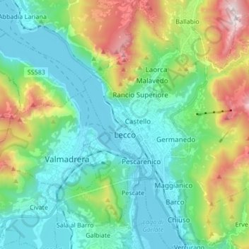
Name: Lecco topographic map, elevation, terrain.
Location: Lecco, Lombardy, 23900, Italy (45.81219 9.36677 45.90614 9.48490)
Average elevation: 575 m
Minimum elevation: 193 m
Maximum elevation: 1,647 m
Make a donation
Gear up for your next adventure:
As an Amazon Associate, this site earns from qualifying purchases at no extra cost to you.
Other topographic maps
Click on a map to view its topography, its elevation and its terrain.
Make a donation
Gear up for your next adventure:
As an Amazon Associate, this site earns from qualifying purchases at no extra cost to you.