Geolocate

Genteng topographic map

Click on the map to display elevation.

About this map
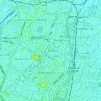
Name: Genteng topographic map, elevation, terrain.

Location: Genteng, Surabaya, East Java, Indonesia (-7.27734 112.73318 -7.24346 112.75331)

Average elevation: 6 m

Minimum elevation: 2 m

Maximum elevation: 18 m

Other topographic maps

Click on a map to view its topography, its elevation and its terrain.
Caribbean Island

Indonesia > East Java > Surabaya > Keputih

Average elevation: 0 m

Taman Harmoni

Indonesia > East Java > Surabaya

Average elevation: 2 m

Taman Flora

Indonesia > East Java > Surabaya > Baratajaya

Average elevation: 5 m

Taman Suroboyo

Indonesia > East Java > Surabaya > Kedung Cowek

Average elevation: 1 m

Caribbean Island

Indonesia > East Java > Surabaya

Average elevation: 0 m

Canberra

Indonesia > East Java > Surabaya > Manukan Wetan

Average elevation: 4 m

Taman Pelangi

Indonesia > East Java > Surabaya > Gayungan

Average elevation: 6 m

Gear up for your next adventure:

💧Hydration Pack - Hands-free hydration system for long hikes
🧦Outdoor Socks - Durable socks designed for hiking and outdoor sports
🎒Fully Waterproof Backpack - Total protection for photography gear and electronics
💧Filtered Water Bottle - Safe drinking water on the go
🥽Outdoor Goggles - Protective eyewear for outdoor activities

As an Amazon Associate, this site earns from qualifying purchases at no extra cost to you.