Geolocate

Coblong topographic map

Click on the map to display elevation.

About this map

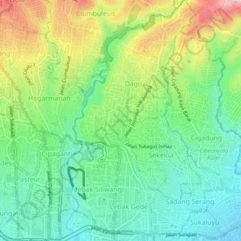
Name: Coblong topographic map, elevation, terrain.

Location: Coblong, Bandung City, West Java, Java, Indonesia (-6.90033 107.60122 -6.86159 107.63072)

Average elevation: 798 m

Minimum elevation: 710 m

Maximum elevation: 961 m

Other topographic maps

Click on a map to view its topography, its elevation and its terrain.

Dago Atas Sideway

Indonesia > West Java > Bandung City > Dago

Average elevation: 830 m

Kiara Artha Park

Indonesia > West Java > Bandung City > Kebonwaru

Average elevation: 690 m

Gear up for your next adventure:

🥾Hiking Shoes - Durable and comfortable shoes for trail hiking
🥾Lightweight Hiking Boots - Boots for comfort and mobility on long hikes
🧭GPS Handheld Device - Reliable GPS navigation for outdoor adventures
Camping Groundsheet - Protect your tent from moisture and dirt
💧Hydration Pack - Hands-free hydration system for long hikes

As an Amazon Associate, this site earns from qualifying purchases at no extra cost to you.