
Make a donation
Gear up for your next adventure:
As an Amazon Associate, this site earns from qualifying purchases at no extra cost to you.
Mundwa topographic map
Click on the map to display elevation.
Make a donation
Gear up for your next adventure:
As an Amazon Associate, this site earns from qualifying purchases at no extra cost to you.
Mundwa
Mundwa is located at 27°04′N 73°49′E / 27.07°N 73.82°E / 27.07; 73.82. It has an average elevation of 335 metres (1099 feet). There are four Talabs on all the four directions of Mundwa. Names of these Talabs are
Make a donation
Gear up for your next adventure:
As an Amazon Associate, this site earns from qualifying purchases at no extra cost to you.
About this map
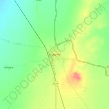
Name: Mundwa topographic map, elevation, terrain.
Location: Mundwa, Mundwa Tehsil, Nagaur, Rajasthan, India (27.02281 73.78170 27.10281 73.86170)
Average elevation: 332 m
Minimum elevation: 304 m
Maximum elevation: 377 m
Make a donation
Gear up for your next adventure:
As an Amazon Associate, this site earns from qualifying purchases at no extra cost to you.