Geolocate

Prisojnik topographic map

Click on the map to display elevation.

About this map

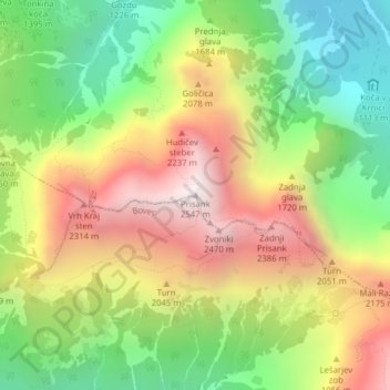
Name: Prisojnik topographic map, elevation, terrain.

Location: Prisojnik, Kranjska Gora, Slovenia (46.42465 13.76966 46.42475 13.76976)

Average elevation: 1,712 m

Minimum elevation: 1,025 m

Maximum elevation: 2,521 m

Other topographic maps

Click on a map to view its topography, its elevation and its terrain.

Planica

Slovenia > Kranjska Gora

Average elevation: 1,325 m

Tamar

Slovenia > Kranjska Gora

Average elevation: 1,674 m

Tamar

Slovenia > Kranjska Gora

Average elevation: 1,674 m

Gear up for your next adventure:

🛶Kayak Dry Bag - Waterproof storage for kayaking adventures
Camping Coffee Maker - Brew fresh coffee anywhere on the topographic map
🧴Bear Spray Holster - Quick-access carry for essential Canadian wilderness safety
🥾Mountain Hiking Boots - High-traction boots for rocky terrain
🚲Heavy Duty Bike Lock - Secure your bike at the trailhead or during stops

As an Amazon Associate, this site earns from qualifying purchases at no extra cost to you.