Geolocate

Neermoor topographic map

Click on the map to display elevation.

About this map
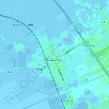
Name: Neermoor topographic map, elevation, terrain.

Location: Neermoor, Moormerland, Landkreis Leer, Nedersaksen, 26802, Duitsland (53.28623 7.39437 53.32917 7.49048)

Average elevation: 0 m

Minimum elevation: -6 m

Maximum elevation: 6 m

Other topographic maps

Click on a map to view its topography, its elevation and its terrain.

Ödenfeld

Duitsland > Nedersaksen > Landkreis Leer > Weener > Holthusen

Average elevation: 3 m

Wymeer

Duitsland > Nedersaksen > Landkreis Leer

Average elevation: 1 m

Stapelmoor

Duitsland > Nedersaksen > Landkreis Leer > Weener

Average elevation: 3 m

Bunderhee

Duitsland > Nedersaksen > Landkreis Leer

Average elevation: 1 m

Gear up for your next adventure:

🥾Approach Shoes - Shoes designed for climbing approaches and rugged trails
🕶️Polarized Sunglasses - Reduces glare from snow and water at high elevations
🧭GPS Outdoor Watch - Smart watch for navigation and fitness tracking in nature
👖Convertible Hiking Pants - Zip-off legs to adapt to changing weather conditions
🚲Handlebar Phone Mount - View topographic-map.com live while cycling

As an Amazon Associate, this site earns from qualifying purchases at no extra cost to you.