Geolocate

Loop topographic map

Click on the map to display elevation.

About this map

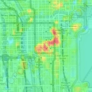
Name: Loop topographic map, elevation, terrain.

Location: Loop, Chicago, Cook County, Illinois, United States (41.86730 -87.63825 41.89064 -87.60248)

Average elevation: 184 m

Minimum elevation: 165 m

Maximum elevation: 223 m

Other topographic maps

Click on a map to view its topography, its elevation and its terrain.

Cascade Park

United States > Illinois > Cook County > Chicago

Average elevation: 182 m

Goose Island

United States > Illinois > Cook County > Chicago

Average elevation: 182 m

Grant Park

United States > Illinois > Cook County > Chicago

Average elevation: 182 m

Durkin Park

United States > Illinois > Cook County > Chicago

Average elevation: 190 m

Ogden Slip

United States > Illinois > Cook County > Chicago

Average elevation: 181 m

Evergreen Park

United States > Illinois > Cook County > Chicago

Average elevation: 183 m

Columbia Basin

United States > Illinois > Cook County > Chicago

Average elevation: 180 m

Gear up for your next adventure:

🧢Hiking Hat - Sun-protective and breathable hats for long treks
🛶Kayak Dry Bag - Waterproof storage for kayaking adventures
🔦LED Flashlight - Powerful and long-lasting flashlight for camping and emergencies
💡LED Headlamp - Hands-free illumination for night hiking and camping
🥾Trail Hiking Boots - Supportive boots for rough trails

As an Amazon Associate, this site earns from qualifying purchases at no extra cost to you.