
San Martín de Porres topographic map
Interactive map
Click on the map to display elevation.
About this map
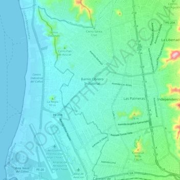
Name: San Martín de Porres topographic map, elevation, terrain.
Location: San Martín de Porres, Lima, Peru (-12.03894 -77.12843 -11.93431 -77.04347)
Average elevation: 55 m
Minimum elevation: -1 m
Maximum elevation: 389 m
Der Distrikt San Martín de Porres ist einer der 43 Stadtbezirke der Region Lima Metropolitana in Peru. Er hat eine Fläche von 36,91 km². Beim Zensus 2017 wurden 654.083 Einwohner gezählt. Im Jahr 1993 lag die Einwohnerzahl bei 380.384, im Jahr 2007 bei 579.561. Der Distrikt wurde am 22. Mai 1950 gegründet. Die Distriktverwaltung liegt auf einer Höhe von 123 m. Die Nationalstraße 1N (Panamericana) führt durch den Südosten des Distrikts.
Other topographic maps
Click on a map to view its topography, its elevation and its terrain.