Geolocate

Cartagena topographic map

Click on the map to display elevation.

About this map

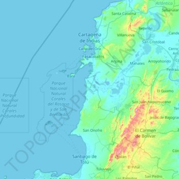
Name: Cartagena topographic map, elevation, terrain.

Location: Cartagena, Dique, Bolívar, RAP Caribe, Colombia (9.37776 -76.19046 10.70378 -75.28720)

Average elevation: 50 m

Minimum elevation: -2 m

Maximum elevation: 784 m

Gear up for your next adventure:

🥾Trail Hiking Shoes - Durable shoes designed for rugged trails
🥤Collapsible Travel Cup - Saves space and weight in your mess kit
🔨Vehicle Emergency Tool - Safety tool for remote road trips to trailheads
🥘Camping Cookware Set - Compact nesting pots and pans for trail cooking
🥾Approach Shoes - Shoes designed for climbing approaches and rugged trails

As an Amazon Associate, this site earns from qualifying purchases at no extra cost to you.