
Make a donation
Gear up for your next adventure:
As an Amazon Associate, this site earns from qualifying purchases at no extra cost to you.
Ribiers topographic map
Click on the map to display elevation.
Make a donation
Gear up for your next adventure:
As an Amazon Associate, this site earns from qualifying purchases at no extra cost to you.
Ribiers
Au XII siècle, l’abbaye Saint-André de Villeneuve-lès-Avignon y possède l’église Sainte-Marie, au château de Creissint (près de Clarescombes, à 961 m d’altitude). Cette église et les revenus qui y étaient attachés sont ensuite cédés à l’ordre de Chalais (1193), puis aux hospitaliers de Saint-Jean de Jérusalem.
Make a donation
Gear up for your next adventure:
As an Amazon Associate, this site earns from qualifying purchases at no extra cost to you.
About this map
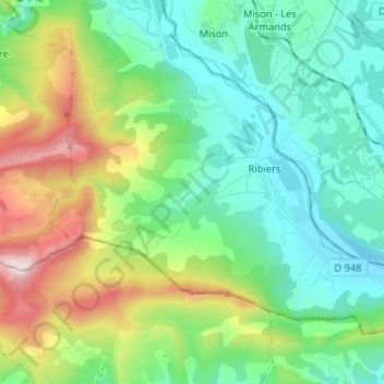
Name: Ribiers topographic map, elevation, terrain.
Average elevation: 680 m
Minimum elevation: 466 m
Maximum elevation: 1,455 m
Make a donation
Gear up for your next adventure:
As an Amazon Associate, this site earns from qualifying purchases at no extra cost to you.
Other topographic maps
Click on a map to view its topography, its elevation and its terrain.
Grange Neuve
France > Provence-Alpes-Côte d'Azur > Hautes-Alpes > Val-Buëch-Méouge
Average elevation: 653 m