Geolocate

Heerlen topographic map

Click on the map to display elevation.

Heerlen

Heerlen's high elevation makes it one of the highest cities above sea level in the Netherlands.

Wikipedia (CC-BY-SA 3.0)

About this map

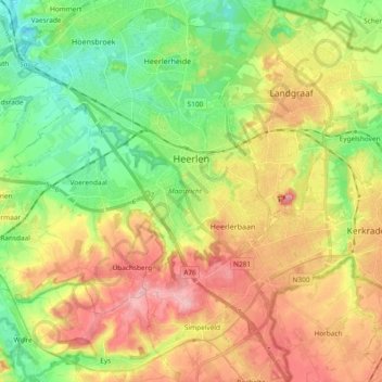
Name: Heerlen topographic map, elevation, terrain.

Location: Heerlen, Limburg, Netherlands (50.81840 5.89541 50.93661 6.02638)

Average elevation: 131 m

Minimum elevation: 62 m

Maximum elevation: 217 m

Other topographic maps

Click on a map to view its topography, its elevation and its terrain.

Maastricht

Netherlands > Limburg > Maastricht

Average elevation: 101 m

Gear up for your next adventure:

🥾Trail Running Shoes - Lightweight and durable shoes for trail running
🎒Backpack Rain Cover - External shield to keep your entire pack dry
Family Camping Tent - Spacious tent suitable for family camping trips
🎒Fully Waterproof Backpack - Total protection for photography gear and electronics
🔭Compact Binoculars - Lightweight optics for scouting trails and wildlife

As an Amazon Associate, this site earns from qualifying purchases at no extra cost to you.