Geolocate

Murtha topographic map

Click on the map to display elevation.

About this map

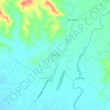
Name: Murtha topographic map, elevation, terrain.

Location: Murtha, San Jose, Occidental Mindoro, Mimaropa, Philippines (12.41634 121.07868 12.45634 121.11868)

Average elevation: 30 m

Minimum elevation: 16 m

Maximum elevation: 85 m

Other topographic maps

Click on a map to view its topography, its elevation and its terrain.

Labangan

Philippines > Occidental Mindoro > San Jose > Mabini

Average elevation: 4 m

Gear up for your next adventure:

🔭Compact Binoculars - Lightweight optics for scouting trails and wildlife
🥾Waterproof Hiking Boots - Boots keeping your feet dry in wet conditions
🧤Insulated Winter Gloves - Heavy-duty protection for sub-zero Canadian adventures
🥾Hiking Gaiters - Protect legs and shoes from mud, snow, and debris
🔦LED Headlamp - Hands-free lighting for early morning starts or late finishes

As an Amazon Associate, this site earns from qualifying purchases at no extra cost to you.