Geolocate

Tienen topographic map

Click on the map to display elevation.

About this map
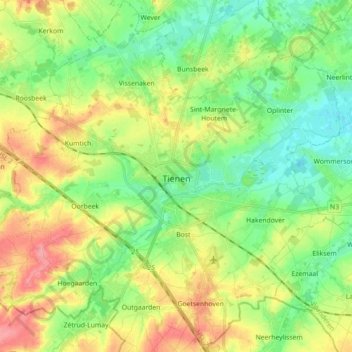
Name: Tienen topographic map, elevation, terrain.

Location: Tienen, Leuven, Flemish Brabant, Flanders, 3300, Belgium (50.75209 4.85172 50.86433 5.01987)

Average elevation: 60 m

Minimum elevation: 28 m

Maximum elevation: 108 m

Other topographic maps

Click on a map to view its topography, its elevation and its terrain.
Leuven

Belgium > Flemish Brabant > Leuven > Leuven

Average elevation: 50 m

Bos

Belgium > Flemish Brabant > Leuven > Zoutleeuw

Average elevation: 31 m

Orsmaal

Belgium > Flemish Brabant > Leuven

Average elevation: 44 m

Optielt

Belgium > Flemish Brabant > Leuven > Tielt

Average elevation: 51 m

Butsel

Belgium > Flemish Brabant > Leuven > Boutersem

Average elevation: 66 m

Beneden-Kessel

Belgium > Flemish Brabant > Leuven > Leuven > Kessel-Lo

Average elevation: 34 m

Ourodenberg

Belgium > Flemish Brabant > Leuven > Aarschot

Average elevation: 16 m

Stadspark

Belgium > Flemish Brabant > Leuven > Aarschot

Average elevation: 24 m

Gear up for your next adventure:

🦌Outdoor Trail Camera - Monitor wildlife activity near your favorite spots
🧼Travel Hand Sanitizer - Keep hands clean when water is scarce
🛏️Camping Sleeping Mat - Comfortable mats for sleeping outdoors
🚲MTB Frame Bag - Carry tools and maps directly on your bicycle frame
🧥Softshell Jacket - Windproof and breathable jacket for hiking

As an Amazon Associate, this site earns from qualifying purchases at no extra cost to you.