Geolocate

Godod topographic map

Click on the map to display elevation.

About this map

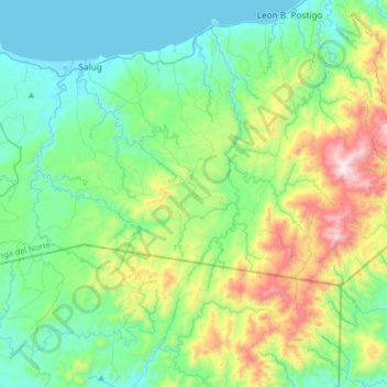
Name: Godod topographic map, elevation, terrain.

Location: Godod, Zamboanga del Norte, Zamboanga Peninsula, Philippines (7.96191 122.80388 8.04191 122.88388)

Average elevation: 311 m

Minimum elevation: 146 m

Maximum elevation: 594 m

Other topographic maps

Click on a map to view its topography, its elevation and its terrain.

Sibuco

Philippines > Zamboanga del Norte

Average elevation: 177 m

Dapitan River

Philippines > Zamboanga del Norte

Average elevation: 293 m

Sibuco

Philippines > Zamboanga del Norte

Average elevation: 177 m

Sibuco

Philippines > Zamboanga del Norte

Average elevation: 177 m

Sibuco

Philippines > Zamboanga del Norte

Average elevation: 177 m

Gear up for your next adventure:

🧥Packable Rain Jacket - Breathable waterproof layer for unpredictable weather
🥾Durable Hiking Shoes - Long-lasting shoes for frequent hiking
🔪Outdoor Multitool - Versatile tool for repairs and food prep in the wild
🔥Emergency Fire Starter - Reliable ignition source for all weather conditions
🧳Compression Sacks - Maximize space in your backpack by shrinking gear

As an Amazon Associate, this site earns from qualifying purchases at no extra cost to you.