Geolocate

Pacentro topographic map

Click on the map to display elevation.

About this map

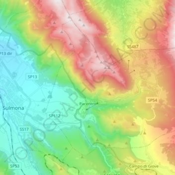
Name: Pacentro topographic map, elevation, terrain.

Location: Pacentro, L'Aquila, Abruzzo, Italy (42.01718 13.95448 42.10344 14.10494)

Average elevation: 998 m

Minimum elevation: 345 m

Maximum elevation: 2,018 m

Gear up for your next adventure:

🥾Approach Boots - Comfortable boots for hiking and climbing approaches
🧦Hiking Liner Socks - Thin base layer to prevent friction and blisters
🔭Compact Monocular - One-handed bird watching and trail spotting
🔪Outdoor Multitool - Versatile tool for repairs and food prep in the wild
🧦Merino Wool Socks - Moisture-wicking comfort for long-distance hiking

As an Amazon Associate, this site earns from qualifying purchases at no extra cost to you.