Geolocate

Fuente Prieta topographic map

Click on the map to display elevation.

About this map

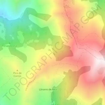
Name: Fuente Prieta topographic map, elevation, terrain.

Location: Fuente Prieta, Lena, Asturias, 33694, España (43.10684 -5.77897 43.12684 -5.75897)

Average elevation: 985 m

Minimum elevation: 539 m

Maximum elevation: 1,399 m

Other topographic maps

Click on a map to view its topography, its elevation and its terrain.

Río Huerna

España > Asturias > Lena

Average elevation: 1,041 m

Riospaso

España > Asturias > Lena

Average elevation: 1,115 m

Gear up for your next adventure:

🥾Hiking Leggings - Comfortable leggings for outdoor activities
🧥Thermal Layer - Insulating layer for cold outdoor conditions
💧Collapsible Water Bottle - Space-saving water bottle for outdoor activities
🔨Vehicle Emergency Tool - Safety tool for remote road trips to trailheads
🩹Moleskin Blister Pads - Direct protection for painful foot pressure points

As an Amazon Associate, this site earns from qualifying purchases at no extra cost to you.