Rio de Janeiro topographic map
Click on the map to display elevation.
Rio de Janeiro
The entire state is located within the tropics (the Tropic of Capricorn passes just a few kilometers south of the state's southernmost point) so a tropical climate is predominant. However, due to altitude, temperatures can drop to freezing point or below in some parts. Frost is not uncommon in some mountainous cities such as Teresópolis, Nova Friburgo and Petrópolis and snow has been reported occasionally in the Itatiaia National Park.
About this map
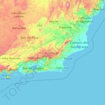
Name: Rio de Janeiro topographic map, elevation, terrain.
Location: Rio de Janeiro, Southeast Region, Brazil (-23.69269 -44.88932 -20.76321 -40.62963)
Average elevation: 319 m
Minimum elevation: -2 m
Maximum elevation: 2,749 m
Other topographic maps
Click on a map to view its topography, its elevation and its terrain.
Brasília
Brazil > Federal District > Região Integrada de Desenvolvimento do Distrito Federal e Entorno
The city sits at an elevation of 1,000 metres (3,300 ft) and more, high on the Brazilian Highlands in the country's center-western region. Paranoá Lake, a large artificial lake, was built to increase the amount of water available and to maintain the region's humidity. It has a marina, and hosts wakeboarders…
Average elevation: 1,084 m


Pelotas
Brazil > Rio Grande do Sul > Aglomeração Urbana do Sul > Pelotas
As it is situated on a plain near the ocean, the urban area lies on a low elevation, being, on average, 7 meters (23 ft) above sea level. The interior of the municipality is on a plateau called Serras de Sudeste (Southeastern Mountain Ranges). Consequently, the altitude in Pelotas' rural area reaches 429…
Average elevation: 18 m