
Make a donation
Gear up for your next adventure:
As an Amazon Associate, this site earns from qualifying purchases at no extra cost to you.
la Seu d'Urgell topographic map
Click on the map to display elevation.
Make a donation
Gear up for your next adventure:
As an Amazon Associate, this site earns from qualifying purchases at no extra cost to you.
About this map
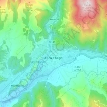
Name: la Seu d'Urgell topographic map, elevation, terrain.
Location: la Seu d'Urgell, Alt Urgell, Lleida, Catalonia, Spain (42.33545 1.42672 42.38436 1.50831)
Average elevation: 845 m
Minimum elevation: 643 m
Maximum elevation: 1,450 m
Make a donation
Gear up for your next adventure:
As an Amazon Associate, this site earns from qualifying purchases at no extra cost to you.
Other topographic maps
Click on a map to view its topography, its elevation and its terrain.
Bony de Serena
Spain > Catalonia > Alt Urgell > les Valls de Valira > Bordes de Jussà
Average elevation: 1,795 m
Make a donation
Gear up for your next adventure:
As an Amazon Associate, this site earns from qualifying purchases at no extra cost to you.