
Thank you for supporting this site ❤️
Make a donation
Make a donation
Gear up for your next adventure:
As an Amazon Associate, this site earns from qualifying purchases at no extra cost to you.
Canin topographic map
Click on the map to display elevation.
Thank you for supporting this site ❤️
Make a donation
Make a donation
Gear up for your next adventure:
As an Amazon Associate, this site earns from qualifying purchases at no extra cost to you.
About this map
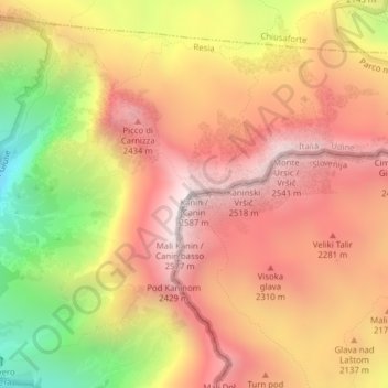
Name: Canin topographic map, elevation, terrain.
Location: Canin, Resia, Udine, Friuli-Venezia Giulia, 33010, Italia (46.36014 13.43897 46.36024 13.43907)
Average elevation: 2,048 m
Minimum elevation: 1,275 m
Maximum elevation: 2,560 m
Thank you for supporting this site ❤️
Make a donation
Make a donation
Gear up for your next adventure:
As an Amazon Associate, this site earns from qualifying purchases at no extra cost to you.