
Make a donation
Gear up for your next adventure:
As an Amazon Associate, this site earns from qualifying purchases at no extra cost to you.
Fondettes topographic map
Click on the map to display elevation.
Make a donation
Gear up for your next adventure:
As an Amazon Associate, this site earns from qualifying purchases at no extra cost to you.
Fondettes
Le relief de Fondettes, notamment marqué par la présence du lit de la Loire et celui de la Choisille, s'élève à une altitude variant entre 42 m, en son point le plus bas, et 100 m, en son point culminant. Par ailleurs, la cote observée au niveau de l'hôtel de ville est établie à environ 94 m.
Make a donation
Gear up for your next adventure:
As an Amazon Associate, this site earns from qualifying purchases at no extra cost to you.
About this map
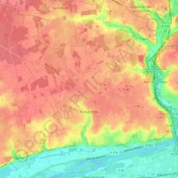
Name: Fondettes topographic map, elevation, terrain.
Average elevation: 81 m
Minimum elevation: 39 m
Maximum elevation: 105 m
Make a donation
Gear up for your next adventure:
As an Amazon Associate, this site earns from qualifying purchases at no extra cost to you.
Other topographic maps
Click on a map to view its topography, its elevation and its terrain.
Le Point du Jour
France > Centre-Val de Loire > Indre-et-Loire > Sainte-Maure-de-Touraine
Average elevation: 100 m
Le Gros Ormeau
France > Centre-Val de Loire > Indre-et-Loire > Cléré-les-Pins
Average elevation: 102 m
Make a donation
Gear up for your next adventure:
As an Amazon Associate, this site earns from qualifying purchases at no extra cost to you.
Les Évées
France > Centre-Val de Loire > Indre-et-Loire > Saint-Martin-le-Beau
Average elevation: 71 m
La Ville
France > Centre-Val de Loire > Indre-et-Loire > Sainte-Maure-de-Touraine
Average elevation: 97 m
Château
France > Centre-Val de Loire > Indre-et-Loire > Sainte-Maure-de-Touraine > La Ville
Average elevation: 92 m
Make a donation
Gear up for your next adventure:
As an Amazon Associate, this site earns from qualifying purchases at no extra cost to you.