
Thank you for supporting this site ❤️
Make a donation
Make a donation
Gear up for your next adventure:
As an Amazon Associate, this site earns from qualifying purchases at no extra cost to you.
Filyos topographic map
Click on the map to display elevation.
Thank you for supporting this site ❤️
Make a donation
Make a donation
Gear up for your next adventure:
As an Amazon Associate, this site earns from qualifying purchases at no extra cost to you.
About this map
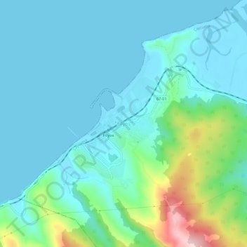
Name: Filyos topographic map, elevation, terrain.
Location: Filyos, Çaycuma, Zonguldak, Black Sea Region, 67970, Turkey (41.54095 32.00466 41.58095 32.04466)
Average elevation: 51 m
Minimum elevation: -4 m
Maximum elevation: 280 m
Thank you for supporting this site ❤️
Make a donation
Make a donation
Gear up for your next adventure:
As an Amazon Associate, this site earns from qualifying purchases at no extra cost to you.