
Make a donation
Gear up for your next adventure:
As an Amazon Associate, this site earns from qualifying purchases at no extra cost to you.
Hilter topographic map
Click on the map to display elevation.
Make a donation
Gear up for your next adventure:
As an Amazon Associate, this site earns from qualifying purchases at no extra cost to you.
Hilter
Zum Namen gibt es verschiedene Interpretationen. Zum einen heißt es, im Namen Hilter sei als Grundwort ter enthalten. Damit sei ein auf einer Wurzel stehender Baum oder Strauch gemeint. Das alte Helderi bedeute etwa: der Ort, in dem Fliederbäume stehen. Es gibt aber auch folgende Version: Vorsilbe Hil = Helle (Hiele) = Berghöhe, verwandt mit Hüls, hils = Berg; tere bedeute grünender Baum (siehe oben). Hilter wäre dann das „Dorf an der grünenden Waldhöhe“.
Make a donation
Gear up for your next adventure:
As an Amazon Associate, this site earns from qualifying purchases at no extra cost to you.
About this map
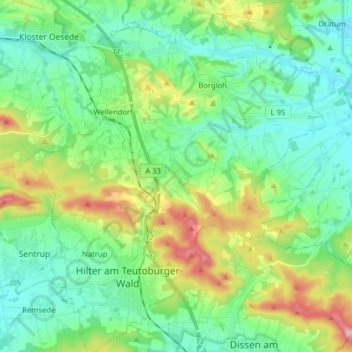
Name: Hilter topographic map, elevation, terrain.
Location: Hilter, Landkreis Osnabrück, Niedersachsen, 49176, Deutschland (52.11708 8.10776 52.21437 8.23596)
Average elevation: 140 m
Minimum elevation: 80 m
Maximum elevation: 297 m
Make a donation
Gear up for your next adventure:
As an Amazon Associate, this site earns from qualifying purchases at no extra cost to you.