Geolocate

Abu Zenima topographic map

Click on the map to display elevation.

About this map

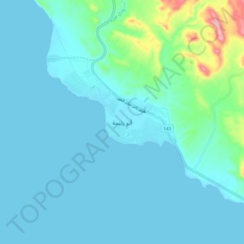
Name: Abu Zenima topographic map, elevation, terrain.

Location: Abu Zenima, South Sinai, Egypt (29.01116 33.06406 29.09116 33.14406)

Average elevation: 40 m

Minimum elevation: 0 m

Maximum elevation: 319 m

Other topographic maps

Click on a map to view its topography, its elevation and its terrain.

Al Tour City

Egypt > South Sinai

Average elevation: 50 m

Ras Sudr

Egypt > South Sinai

Average elevation: 17 m

Ras Muhammad National Park

Egypt > South Sinai

Average elevation: 112 m

Wadi Khuraytah

Egypt > South Sinai > Saint Catherine

Average elevation: 1,323 m

Ras Sudr

Egypt > South Sinai

Average elevation: 17 m

Gear up for your next adventure:

🧴Sunscreen SPF - Broad-spectrum sunscreen for outdoor activities
🎒Hiking Backpack - Lightweight and ergonomic backpacks for day hikes or multi-day treks
🧭Orienteering Kit - Tools for map reading and navigation in the wild
🔦LED Headlamp - Hands-free lighting for early morning starts or late finishes
💡LED Headlamp - Hands-free illumination for night hiking and camping

As an Amazon Associate, this site earns from qualifying purchases at no extra cost to you.