Geolocate

Aleosan topographic map

Click on the map to display elevation.

About this map

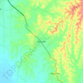
Name: Aleosan topographic map, elevation, terrain.

Location: Aleosan, North Cotabato, Soccsksargen, 9415, Philippines (7.11858 124.53740 7.19858 124.61740)

Average elevation: 44 m

Minimum elevation: 5 m

Maximum elevation: 125 m

Other topographic maps

Click on a map to view its topography, its elevation and its terrain.

Lake Jordan

Philippines > North Cotabato > Makilala

Average elevation: 2,383 m

President Roxas

Philippines > North Cotabato

Average elevation: 364 m

Gear up for your next adventure:

🔪Outdoor Multitool - Versatile tool for repairs and food prep in the wild
🧴Bear Spray Holster - Quick-access carry for essential Canadian wilderness safety
🥾Hiking Boots - Sturdy boots providing ankle support and traction on rugged trails
🥾Trekking Boots - Durable boots for long-distance trekking
🧰Emergency Multi-Tool - Compact multi-tool for outdoor survival

As an Amazon Associate, this site earns from qualifying purchases at no extra cost to you.