Geolocate

Kadakkal topographic map

Click on the map to display elevation.

About this map

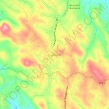
Name: Kadakkal topographic map, elevation, terrain.

Location: Kadakkal, Kottarakkara, Kollam District, Kerala, 691536, India (8.81365 76.90270 8.85365 76.94270)

Average elevation: 129 m

Minimum elevation: 55 m

Maximum elevation: 191 m

Other topographic maps

Click on a map to view its topography, its elevation and its terrain.

Kizhakkumbhagom kulam

India > Kerala > Kottarakkara > Chithara

Average elevation: 163 m

Gear up for your next adventure:

💧Reusable Water Bottle - Durable water bottles for hydration on trails
🧥Waterproof Jacket - Lightweight rain jackets for hiking and outdoor activities
🧤Insulated Winter Gloves - Heavy-duty protection for sub-zero Canadian adventures
🥾Trail Hiking Socks - Comfortable socks to prevent blisters and fatigue
🔭Compact Monocular - One-handed bird watching and trail spotting

As an Amazon Associate, this site earns from qualifying purchases at no extra cost to you.