Geolocate

Tanis topographic map

Click on the map to display elevation.

About this map
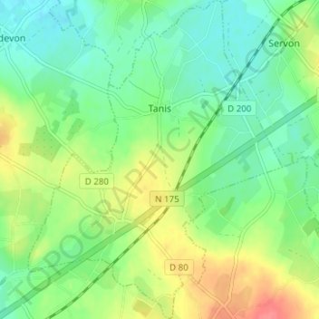
Name: Tanis topographic map, elevation, terrain.

Location: Tanis, Avranches, Manche, Normandy, Metropolitan France, 50170, France (48.56499 -1.46943 48.60615 -1.41978)

Average elevation: 26 m

Minimum elevation: 4 m

Maximum elevation: 64 m

Other topographic maps

Click on a map to view its topography, its elevation and its terrain.
Le Petit Hameau

France > Normandy > Manche > Barneville-Carteret

Average elevation: 21 m

Le Clos Versailles

France > Normandy > Manche > La Haye-du-Puits

Average elevation: 51 m

Le Valnotte

France > Normandy > Manche > Carteret

Average elevation: 35 m

Gear up for your next adventure:

🧳Compression Sacks - Maximize space in your backpack by shrinking gear
🎒Backpack Rain Cover - External shield to keep your entire pack dry
🥾Mountaineering Boots - Supportive boots for climbing and high-altitude hiking
💧Collapsible Water Bottle - Space-saving water bottle for outdoor activities
🛶Kayak Dry Bag - Waterproof storage for kayaking adventures

As an Amazon Associate, this site earns from qualifying purchases at no extra cost to you.