
Zeitlarn topographic map
Click on the map to display elevation.
About this map
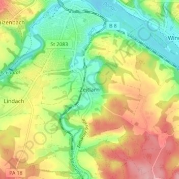
Name: Zeitlarn topographic map, elevation, terrain.
Average elevation: 353 m
Minimum elevation: 298 m
Maximum elevation: 420 m
Other topographic maps
Click on a map to view its topography, its elevation and its terrain.
94474
Deutschland > Bayern > Landkreis Passau > Vilshofen an der Donau > Waizenbach > Dorf
Average elevation: 370 m
94474
Deutschland > Bayern > Landkreis Passau > Vilshofen an der Donau > Waizenbach > Dorf
Average elevation: 370 m