
Thank you for supporting this site ❤️
Make a donation
Make a donation
Gear up for your next adventure:
As an Amazon Associate, this site earns from qualifying purchases at no extra cost to you.
Kotturu topographic map
Click on the map to display elevation.
Thank you for supporting this site ❤️
Make a donation
Make a donation
Gear up for your next adventure:
As an Amazon Associate, this site earns from qualifying purchases at no extra cost to you.
About this map
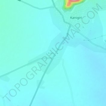
Name: Kotturu topographic map, elevation, terrain.
Location: Kotturu, Kanigiri, Prakasam, Andhra Pradesh, 523230, India (15.37301 79.47762 15.41301 79.51762)
Average elevation: 106 m
Minimum elevation: 89 m
Maximum elevation: 260 m
Thank you for supporting this site ❤️
Make a donation
Make a donation
Gear up for your next adventure:
As an Amazon Associate, this site earns from qualifying purchases at no extra cost to you.