Geolocate

Hatton Township topographic map

Click on the map to display elevation.

About this map

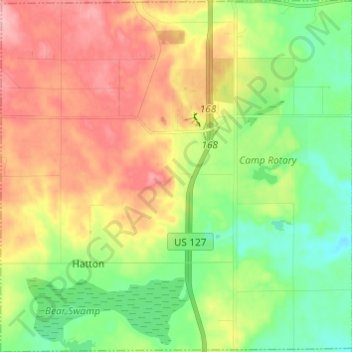
Name: Hatton Township topographic map, elevation, terrain.

Location: Hatton Township, Clare County, Michigan, United States (43.90085 -84.84894 43.98833 -84.72747)

Average elevation: 321 m

Minimum elevation: 267 m

Maximum elevation: 389 m

Other topographic maps

Click on a map to view its topography, its elevation and its terrain.

Lake George

United States > Michigan > Clare County

Average elevation: 346 m

Lake

United States > Michigan > Clare County

Average elevation: 328 m

Allendale

United States > Michigan > Clare County

Average elevation: 344 m

Hatton

United States > Michigan > Clare County

Average elevation: 315 m

Ash Acres

United States > Michigan > Clare County

Average elevation: 361 m

Buck Trails

United States > Michigan > Clare County

Average elevation: 353 m

Colonville

United States > Michigan > Clare County

Average elevation: 252 m

Cooperton

United States > Michigan > Clare County

Average elevation: 336 m

Dover

United States > Michigan > Clare County

Average elevation: 279 m

Leota

United States > Michigan > Clare County

Average elevation: 338 m

Phelps

United States > Michigan > Clare County

Average elevation: 339 m

Rainbow Bend

United States > Michigan > Clare County

Average elevation: 335 m

Temple

United States > Michigan > Clare County

Average elevation: 322 m

Gear up for your next adventure:

Tent Footprint - Protect tent floor and increase durability
🔋Solar Power Bank - Keep your GPS and devices charged during long outdoor trips
🕶️Polarized Sunglasses - Reduces glare from snow and water at high elevations
🏃Hydration Running Vest - Carry water and maps close to your body for speed
🧦Hiking Socks - Moisture-wicking and comfortable socks for long hikes

As an Amazon Associate, this site earns from qualifying purchases at no extra cost to you.