
Make a donation
Gear up for your next adventure:
As an Amazon Associate, this site earns from qualifying purchases at no extra cost to you.
Bedburg-Hau topographic map
Click on the map to display elevation.
Make a donation
Gear up for your next adventure:
As an Amazon Associate, this site earns from qualifying purchases at no extra cost to you.
About this map
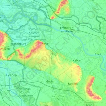
Name: Bedburg-Hau topographic map, elevation, terrain.
Average elevation: 21 m
Minimum elevation: 6 m
Maximum elevation: 101 m
Make a donation
Gear up for your next adventure:
As an Amazon Associate, this site earns from qualifying purchases at no extra cost to you.
Other topographic maps
Click on a map to view its topography, its elevation and its terrain.
Kleve
Deutschland > Nordrhein-Westfalen > Kreis Kleve > Kleve
Kleve gehört geografisch zur Unteren Rheinniederung und zu den Niederrheinischen Höhen, beides Teile des Niederrheinischen Tieflands.
Average elevation: 39 m
Make a donation
Gear up for your next adventure:
As an Amazon Associate, this site earns from qualifying purchases at no extra cost to you.
Kevelaer
Deutschland > Nordrhein-Westfalen > Kreis Kleve
War Kevelaer von der Märzrevolution noch kaum betroffen, so änderte sich dies 1871 durch den vom Reichskanzler Otto von Bismarck initiierten Kulturkampf. Zwischen 1871 und 1873 wurden der Kanzelparagraph eingeführt, der Jesuitenorden verboten und zum Höhepunkt des Kulturkampfes die Maigesetze erlassen. Im…
Average elevation: 24 m