Geolocate

Wedowee topographic map

Click on the map to display elevation.

About this map

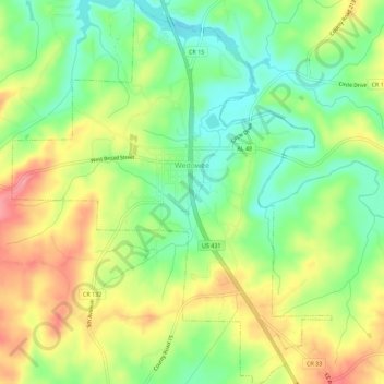
Name: Wedowee topographic map, elevation, terrain.

Location: Wedowee, Randolph County, Alabama, United States (33.28210 -85.51115 33.32919 -85.46418)

Average elevation: 278 m

Minimum elevation: 236 m

Maximum elevation: 329 m

Other topographic maps

Click on a map to view its topography, its elevation and its terrain.

Newell

United States > Alabama > Randolph County

Average elevation: 286 m

Wedowee

United States > Alabama > Randolph County

Average elevation: 278 m

Flat Rock

United States > Alabama > Randolph County

Average elevation: 253 m

Gear up for your next adventure:

💧Collapsible Water Bottle - Space-saving water bottle for outdoor activities
🦯Trekking Poles - Reduced impact on joints for steep topographic climbs
🧦Hiking Liner Socks - Thin base layer to prevent friction and blisters
🕶️Polarized Sunglasses - Protect your eyes with durable polarized lenses
🥾Waterproof Hiking Boots - Essential footwear for rugged terrain and wet Canadian trails

As an Amazon Associate, this site earns from qualifying purchases at no extra cost to you.