Geolocate

Tayuman topographic map

Click on the map to display elevation.

About this map

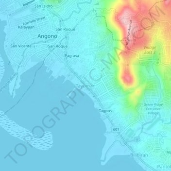
Name: Tayuman topographic map, elevation, terrain.

Location: Tayuman, Binangonan, Rizal, Calabarzon, 1930, Philippines (14.49417 121.14222 14.53417 121.18222)

Average elevation: 33 m

Minimum elevation: -1 m

Maximum elevation: 216 m

Other topographic maps

Click on a map to view its topography, its elevation and its terrain.

Libis

Philippines > Rizal > Binangonan

Average elevation: 10 m

Calumpang

Philippines > Rizal > Binangonan > Macamot

Average elevation: 16 m

Talim

Philippines > Rizal > Binangonan

Average elevation: 13 m

Gear up for your next adventure:

🧣Merino Neck Gaiter - Protects against wind, sun, and cold at high altitudes
🥾Hiking Gaiters - Protect legs and shoes from mud, snow, and debris
🎒Hiking Daypack - Lightweight and durable backpacks for day trips and excursions
👟Leg Gaiters - Keep debris, mud, and snow out of your boots
🥾Waterproof Trail Shoes - Shoes designed to handle wet terrain

As an Amazon Associate, this site earns from qualifying purchases at no extra cost to you.