Geolocate

Hamburg topographic map

Click on the map to display elevation.

About this map

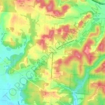
Name: Hamburg topographic map, elevation, terrain.

Location: Hamburg, Hocking Township, Fairfield County, Ohio, United States (39.63451 -82.68072 39.67451 -82.64072)

Average elevation: 317 m

Minimum elevation: 262 m

Maximum elevation: 372 m

Other topographic maps

Click on a map to view its topography, its elevation and its terrain.

Lithopolis

United States > Ohio > Fairfield County

Average elevation: 266 m

West Rushville

United States > Ohio > Fairfield County

Average elevation: 297 m

Thurston

United States > Ohio > Fairfield County

Average elevation: 270 m

Sugar Grove

United States > Ohio > Fairfield County

Average elevation: 258 m

Pleasantville

United States > Ohio > Fairfield County

Average elevation: 277 m

Amanda

United States > Ohio > Fairfield County

Average elevation: 278 m

Carroll

United States > Ohio > Fairfield County

Average elevation: 256 m

Stoutsville

United States > Ohio > Fairfield County

Average elevation: 300 m

Violet Township

United States > Ohio > Fairfield County

Average elevation: 262 m

Gear up for your next adventure:

🧤Rechargeable Heated Gloves - Extreme warmth for Canadian winter expeditions
🧳Compression Sacks - Maximize space in your backpack by shrinking gear
🛶Canoe Life Vest - Safety vest for water sports
💧Hydration Pack - Hands-free hydration system for long hikes
🛶Waterproof Dry Bags - Keep electronics and clothes dry during river crossings

As an Amazon Associate, this site earns from qualifying purchases at no extra cost to you.