Geolocate

South Bend topographic map

Click on the map to display elevation.

About this map

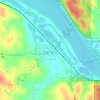
Name: South Bend topographic map, elevation, terrain.

Location: South Bend, Cass County, Nebraska, United States (40.99990 -96.25059 41.00484 -96.24330)

Average elevation: 333 m

Minimum elevation: 313 m

Maximum elevation: 373 m

Gear up for your next adventure:

🚲Handlebar Phone Mount - View topographic-map.com live while cycling
🛁Quick-Dry Microfiber Towel - Space-saving towel that dries rapidly on the move
🥾Approach Shoes - Shoes designed for climbing approaches and rugged trails
🕶️Polarized Sunglasses - Protect your eyes with durable polarized lenses
Family Camping Tent - Spacious tent suitable for family camping trips

As an Amazon Associate, this site earns from qualifying purchases at no extra cost to you.