
Make a donation
Gear up for your next adventure:
As an Amazon Associate, this site earns from qualifying purchases at no extra cost to you.
Kwekwe topographic map
Click on the map to display elevation.
Make a donation
Gear up for your next adventure:
As an Amazon Associate, this site earns from qualifying purchases at no extra cost to you.
Kwekwe
The town is situated on Zimbabwe's Highveld at an altitude of 1,220 metres (4,000 ft), above sea level. It is located in the tropics but its high altitude modifies this to a warm temperate or humid subtropical climate.
Make a donation
Gear up for your next adventure:
As an Amazon Associate, this site earns from qualifying purchases at no extra cost to you.
About this map
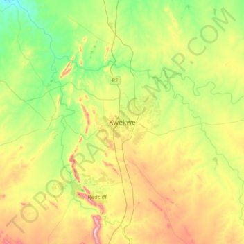
Name: Kwekwe topographic map, elevation, terrain.
Location: Kwekwe, Midlands Province, Zimbabwe (-19.08844 29.65400 -18.76844 29.97400)
Average elevation: 1,200 m
Minimum elevation: 1,086 m
Maximum elevation: 1,380 m
Make a donation
Gear up for your next adventure:
As an Amazon Associate, this site earns from qualifying purchases at no extra cost to you.
Other topographic maps
Click on a map to view its topography, its elevation and its terrain.