Geolocate

Massiac topographic map

Click on the map to display elevation.

About this map

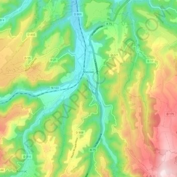
Name: Massiac topographic map, elevation, terrain.

Location: Massiac, Saint-Flour, Cantal, Auvergne-Rhône-Alpes, Metropolitan France, 15500, France (45.20556 3.14389 45.28257 3.24664)

Average elevation: 721 m

Minimum elevation: 512 m

Maximum elevation: 1,034 m

Other topographic maps

Click on a map to view its topography, its elevation and its terrain.

Series

France > Auvergne-Rhône-Alpes > Cantal > Vitrac

Average elevation: 569 m

Lustrande

France > Auvergne-Rhône-Alpes > Cantal > Brezons

Average elevation: 1,213 m

Super Lioran

France > Auvergne-Rhône-Alpes > Cantal

Average elevation: 1,367 m

La Siauve

France > Auvergne-Rhône-Alpes > Cantal > Lanobre

Average elevation: 588 m

La Cabane

France > Auvergne-Rhône-Alpes > Cantal > Glénat > La Cabane

Average elevation: 609 m

Gear up for your next adventure:

🔥Camping Stove - Portable stoves to cook outdoors with ease
🛶Waterproof Dry Bags - Keep electronics and clothes dry during river crossings
🥾Mountain Hiking Shoes - Shoes with superior grip for mountainous terrain
Family Camping Tent - Spacious tent suitable for family camping trips
🧢Beanie Hat - Keep your head warm in cold weather

As an Amazon Associate, this site earns from qualifying purchases at no extra cost to you.