
Make a donation
Gear up for your next adventure:
As an Amazon Associate, this site earns from qualifying purchases at no extra cost to you.
McIndoe Falls topographic map
Click on the map to display elevation.
Make a donation
Gear up for your next adventure:
As an Amazon Associate, this site earns from qualifying purchases at no extra cost to you.
About this map
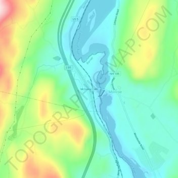
Name: McIndoe Falls topographic map, elevation, terrain.
Average elevation: 222 m
Minimum elevation: 128 m
Maximum elevation: 433 m
Make a donation
Gear up for your next adventure:
As an Amazon Associate, this site earns from qualifying purchases at no extra cost to you.
Other topographic maps
Click on a map to view its topography, its elevation and its terrain.
Make a donation
Gear up for your next adventure:
As an Amazon Associate, this site earns from qualifying purchases at no extra cost to you.
Lyndon
United States > Vermont > Caledonia County
The highest point in Lyndon is Diamond Hill in the southwest, with an elevation of slightly greater than 1,640 feet (500 m).
Average elevation: 317 m
Walden
United States > Vermont > Caledonia County
The highest point in Walden is the summit of Stannard Mountain, near the town's northern border, with an elevation of over 2,579 feet (786 m) above sea level.
Average elevation: 511 m
Make a donation
Gear up for your next adventure:
As an Amazon Associate, this site earns from qualifying purchases at no extra cost to you.
Sutton
United States > Vermont > Caledonia County
The highest point in Sutton is the summit of Mount Hor in the northern corner of town, with an elevation of 2,656 feet (809.5 m) above sea level. The modest elevation of this town gives it a slightly cooler and wetter climate than nearby towns such as St. Johnsbury. Annual snowfall averages well over 100…
Average elevation: 459 m
Wheelock
United States > Vermont > Caledonia County
The highest point in town is Wheelock Mountain, with an elevation of 2,782 feet (848 m).
Average elevation: 412 m
Make a donation
Gear up for your next adventure:
As an Amazon Associate, this site earns from qualifying purchases at no extra cost to you.