
Make a donation
Gear up for your next adventure:
As an Amazon Associate, this site earns from qualifying purchases at no extra cost to you.
Elz topographic map
Click on the map to display elevation.
Make a donation
Gear up for your next adventure:
As an Amazon Associate, this site earns from qualifying purchases at no extra cost to you.
Elz
Elz liegt im Limburger Becken, wobei das Gemeindegebiet in dessen westliche Randhöhen und damit in den Bereich des Niederwesterwaldes (Elzer Wald) hineinreicht. Von Norden nach Süden wird es vom flachhängigen Tal des Elbbachs durchquert, der im Hohen Westerwald entspringt, in Elz vom Erbach gespeist wird und in die südlich der auf 110 bis 291 m ü. NHN gelegenen Ortschaft fließende Lahn mündet.
Make a donation
Gear up for your next adventure:
As an Amazon Associate, this site earns from qualifying purchases at no extra cost to you.
About this map
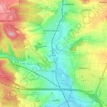
Name: Elz topographic map, elevation, terrain.
Location: Elz, Landkreis Limburg-Weilburg, Hessen, 65604, Deutschland (50.40072 7.96401 50.44516 8.05401)
Average elevation: 175 m
Minimum elevation: 107 m
Maximum elevation: 279 m
Make a donation
Gear up for your next adventure:
As an Amazon Associate, this site earns from qualifying purchases at no extra cost to you.