
Thank you for supporting this site ❤️
Make a donation
Make a donation
Gear up for your next adventure:
As an Amazon Associate, this site earns from qualifying purchases at no extra cost to you.
Antella topographic map
Click on the map to display elevation.
Thank you for supporting this site ❤️
Make a donation
Make a donation
Gear up for your next adventure:
As an Amazon Associate, this site earns from qualifying purchases at no extra cost to you.
About this map
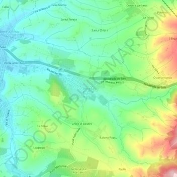
Name: Antella topographic map, elevation, terrain.
Location: Antella, Bagno a Ripoli, Firenze, Toscana, 50012, Italia (43.70728 11.30274 43.74728 11.34274)
Average elevation: 163 m
Minimum elevation: 80 m
Maximum elevation: 340 m
Thank you for supporting this site ❤️
Make a donation
Make a donation
Gear up for your next adventure:
As an Amazon Associate, this site earns from qualifying purchases at no extra cost to you.
Other topographic maps
Click on a map to view its topography, its elevation and its terrain.
I ponti
Italia > Toscana > Firenze > Bagno a Ripoli > Ponte a Ema > Casa Nuova
Average elevation: 92 m