Geolocate

Svino topographic map

Click on the map to display elevation.

About this map

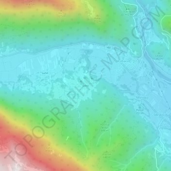
Name: Svino topographic map, elevation, terrain.

Location: Svino, Kobarid, 5222, Slovenia (46.21975 13.54632 46.25975 13.58632)

Average elevation: 463 m

Minimum elevation: 193 m

Maximum elevation: 1,350 m

Gear up for your next adventure:

🚲Heavy Duty Bike Lock - Secure your bike at the trailhead or during stops
🥾Trail Hiking Shoes - Durable shoes designed for rugged trails
🚲Bike Repair Kit - Essential tools for on-trail mechanical issues
🧥Insulated Jacket - Keep warm in cold outdoor conditions
💧Hydration Pack - Hands-free hydration system for long hikes

As an Amazon Associate, this site earns from qualifying purchases at no extra cost to you.