Geolocate

Bogalusa topographic map

Click on the map to display elevation.

Bogalusa

Bogalusa has an elevation of 100 feet (30.5 m).

Wikipedia (CC-BY-SA 3.0)

About this map

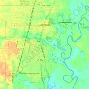
Name: Bogalusa topographic map, elevation, terrain.

Location: Bogalusa, Washington Parish, Louisiana, 70427, United States (30.74681 -89.89600 30.80794 -89.83288)

Average elevation: 29 m

Minimum elevation: 14 m

Maximum elevation: 45 m

Other topographic maps

Click on a map to view its topography, its elevation and its terrain.

Pine

United States > Louisiana > Washington Parish

Average elevation: 93 m

Thomas

United States > Louisiana > Washington Parish

Average elevation: 96 m

Gear up for your next adventure:

🧊Insulated Water Bottle - Keeps drinks cold in summer and prevents freezing in winter
🧰Multitool Knife - Compact and versatile tool for outdoor use
❄️Traction Ice Cleats - Slip-on spikes for icy trails and winter hiking
💧Hydration Bladder - Hands-free hydration solution for long treks
🎒Hiking Backpack - Lightweight and ergonomic backpacks for day hikes or multi-day treks

As an Amazon Associate, this site earns from qualifying purchases at no extra cost to you.