Geolocate

Muthara topographic map

Click on the map to display elevation.

About this map

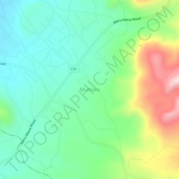
Name: Muthara topographic map, elevation, terrain.

Location: Muthara, Tigania East, Meru County, Eastern, Kenya (0.19660 37.78000 0.23660 37.82000)

Average elevation: 1,524 m

Minimum elevation: 1,377 m

Maximum elevation: 1,856 m

Other topographic maps

Click on a map to view its topography, its elevation and its terrain.

Thangatha ward

Kenya > Meru County > Tigania East

Average elevation: 1,124 m

Gear up for your next adventure:

🥾Mountain Hiking Boots - High-traction boots for rocky terrain
❄️Traction Ice Cleats - Slip-on spikes for icy trails and winter hiking
🚲Bike Repair Kit - Essential tools for on-trail mechanical issues
🥾Light Trekking Boots - Supportive boots for multi-day treks
🛁Quick-Dry Microfiber Towel - Space-saving towel that dries rapidly on the move

As an Amazon Associate, this site earns from qualifying purchases at no extra cost to you.