Geolocate

Acámbaro topographic map

Click on the map to display elevation.

About this map

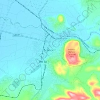
Name: Acámbaro topographic map, elevation, terrain.

Location: Acámbaro, Guanajuato, 38600, Mexico (19.98910 -100.76333 20.06910 -100.68333)

Average elevation: 1,897 m

Minimum elevation: 1,847 m

Maximum elevation: 2,180 m

Gear up for your next adventure:

🧥Fleece Jacket - Warm and lightweight jacket for layering
🧥Thermal Layer - Insulating layer for cold outdoor conditions
Lightweight Camping Tent - Portable shelter optimized for Canadian backcountry camping
🌬️Windproof Camp Stove - Efficient cooking even on exposed mountain peaks
🛁Quick-Dry Microfiber Towel - Space-saving towel that dries rapidly on the move

As an Amazon Associate, this site earns from qualifying purchases at no extra cost to you.