Geolocate

Nahan topographic map

Click on the map to display elevation.

Nahan

Nahan is located at 30°33′N 77°18′E / 30.55°N 77.3°E / 30.55; 77.3. It has an average elevation of 932 metres.

Wikipedia (CC-BY-SA 3.0)

About this map

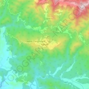
Name: Nahan topographic map, elevation, terrain.

Location: Nahan, Sirmaur District, Himachal Pradesh, India (30.52018 77.25236 30.60018 77.33236)

Average elevation: 685 m

Minimum elevation: 379 m

Maximum elevation: 1,403 m

Gear up for your next adventure:

👟Leg Gaiters - Keep debris, mud, and snow out of your boots
🔥Emergency Fire Starter - Reliable ignition source for all weather conditions
👖Convertible Hiking Pants - Zip-off legs to adapt to changing weather conditions
🚲MTB Frame Bag - Carry tools and maps directly on your bicycle frame
🧤Rechargeable Heated Gloves - Extreme warmth for Canadian winter expeditions

As an Amazon Associate, this site earns from qualifying purchases at no extra cost to you.