
Make a donation
Gear up for your next adventure:
As an Amazon Associate, this site earns from qualifying purchases at no extra cost to you.
Dayton topographic map
Click on the map to display elevation.
Make a donation
Gear up for your next adventure:
As an Amazon Associate, this site earns from qualifying purchases at no extra cost to you.
About this map
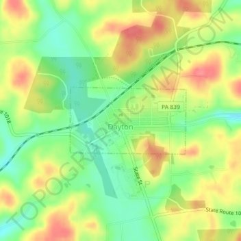
Name: Dayton topographic map, elevation, terrain.
Location: Dayton, Armstrong County, Pennsylvania, 16222, United States (40.87723 -79.24946 40.88475 -79.23226)
Average elevation: 423 m
Minimum elevation: 389 m
Maximum elevation: 458 m
Make a donation
Gear up for your next adventure:
As an Amazon Associate, this site earns from qualifying purchases at no extra cost to you.
Other topographic maps
Click on a map to view its topography, its elevation and its terrain.
Lake Keystone
United States > Pennsylvania > Armstrong County > Plumcreek Township
Keystone Lake (also known as Keystone Reservoir and Plum Creek Reservoir) is a reservoir in Armstrong County in the U.S. state of Pennsylvania. The elevation of Keystone Lake is 1,076 feet (328 m) above sea level.
Average elevation: 357 m
Crooked Creek Lake
United States > Pennsylvania > Armstrong County > Bethel Township
Average elevation: 288 m
Make a donation
Gear up for your next adventure:
As an Amazon Associate, this site earns from qualifying purchases at no extra cost to you.
Slate Lick
United States > Pennsylvania > Armstrong County > South Buffalo Township
Average elevation: 356 m
Williamsburg
United States > Pennsylvania > Armstrong County > East Franklin Township
Average elevation: 319 m