Geolocate

Guanta topographic map

Click on the map to display elevation.

About this map

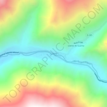
Name: Guanta topographic map, elevation, terrain.

Location: Guanta, Vicuña, Provincia de Elqui, Región de Coquimbo, Chile (-29.86625 -70.41140 -29.82625 -70.37140)

Average elevation: 1,743 m

Minimum elevation: 1,171 m

Maximum elevation: 2,684 m

Other topographic maps

Click on a map to view its topography, its elevation and its terrain.

Gear up for your next adventure:

🪜Heavy Duty Carabiners - Multi-use clips for securing gear to your backpack
🧴Bear Spray Holster - Quick-access carry for essential Canadian wilderness safety
🌬️Windproof Camp Stove - Efficient cooking even on exposed mountain peaks
🔦LED Flashlight - Powerful and long-lasting flashlight for camping and emergencies
🔪Outdoor Multitool - Versatile tool for repairs and food prep in the wild

As an Amazon Associate, this site earns from qualifying purchases at no extra cost to you.