Geolocate

Wheeler topographic map

Click on the map to display elevation.

About this map

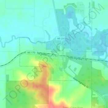
Name: Wheeler topographic map, elevation, terrain.

Location: Wheeler, Dunn County, Wisconsin, United States (45.03810 -91.92050 45.05150 -91.88552)

Average elevation: 288 m

Minimum elevation: 271 m

Maximum elevation: 331 m

Other topographic maps

Click on a map to view its topography, its elevation and its terrain.

Graytown

United States > Wisconsin > Dunn County

Average elevation: 344 m

Caryville

United States > Wisconsin > Dunn County

Average elevation: 241 m

Downsville

United States > Wisconsin > Dunn County

Average elevation: 255 m

Rock Falls

United States > Wisconsin > Dunn County

Average elevation: 265 m

Wilson Park

United States > Wisconsin > Dunn County > Menomonie

Average elevation: 267 m

Canary Island

United States > Wisconsin > Dunn County > Menomonie

Average elevation: 309 m

Gear up for your next adventure:

🧭Orienteering Kit - Tools for map reading and navigation in the wild
🔦LED Headlamp - Hands-free lighting for early morning starts or late finishes
💧Reusable Water Bottle - Durable water bottles for hydration on trails
🏕️Camping Hammock - Integrated protection for sleeping between trees
🥾Lightweight Hiking Boots - Boots for comfort and mobility on long hikes

As an Amazon Associate, this site earns from qualifying purchases at no extra cost to you.