Geolocate

Long Bawan topographic map

Click on the map to display elevation.

About this map

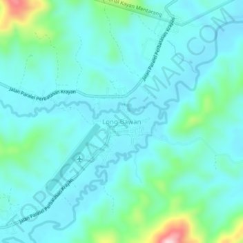
Name: Long Bawan topographic map, elevation, terrain.

Location: Long Bawan, Nunukan, North Kalimantan, Kalimantan, Indonesia (3.88647 115.67824 3.92647 115.71824)

Average elevation: 974 m

Minimum elevation: 925 m

Maximum elevation: 1,220 m

Other topographic maps

Click on a map to view its topography, its elevation and its terrain.

Sebatik Island

Indonesia > North Kalimantan > Nunukan

Average elevation: 24 m

Gear up for your next adventure:

Camping Essentials - All-in-one gear for a comfortable camping trip
🧥Waterproof Jacket - Lightweight rain jackets for hiking and outdoor activities
🩹Moleskin Blister Pads - Direct protection for painful foot pressure points
🔋Emergency Crank Radio - Weather alerts and power without needing batteries
🛶Canoe Life Vest - Safety vest for water sports

As an Amazon Associate, this site earns from qualifying purchases at no extra cost to you.